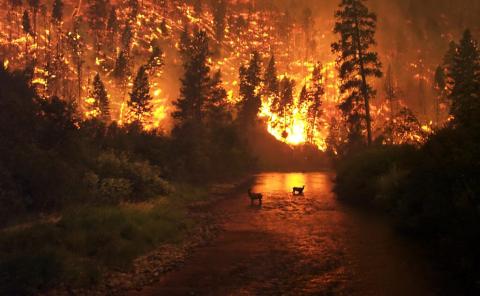
The Problem
Our expanding human footprint and rapidly changing climate are driving widespread environmental impacts at rates and scales that often exceed our ability to monitor, assess, and respond accordingly. A 10-year management plan based on a static map can become quickly outdated by the cumulative effects of our rapidly changing world, limiting its effectiveness in achieving conservation goals. Despite the many conservation successes over the past century, the hard truth is that we continue to lose biodiversity globally.
- Human activity has altered over 75% of all ice-free land and 66% of our oceans, with the majority of impacts occurring over the past few centuries.
- This has led to the loss of over 80% of wild mammal and 50% of native plant biomass, much of that in the past 50 years.
- Nearly 30% of mammals are now at risk of extinction, and 41% of mammals are projected to lose half of their habitat with +3C warming.
What We Do
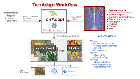
TerrAdapt offers solutions that improve our partner’s capacity to monitor, assess, and communicate the impacts of environmental change at the scales and pace required, anticipate future risks from climate change, and know where to strategically invest limited resources to most effectively address rapidly emerging threats.
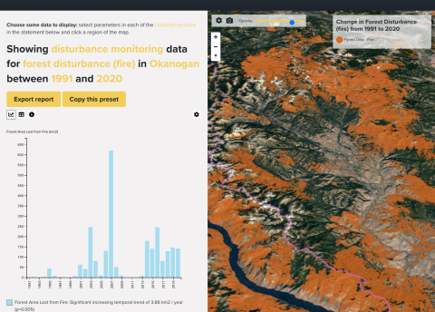
To do so, we build dynamic tools and datasets within a cloud-based workflow that dynamically links remote sensing and other data to the powerful spatial analysis and remote sensing capabilities of Google Earth Engine. Every year, the data you use to inform and prioritize your management decisions, report on status and trends, and communicate the need for action is updated automatically.
Our data pipeline feeds automatically into our dynamic map and dashboard portals where you can visualize historical, current, and projected future conditions, calculate metrics of change over an area and period of interest, and create custom images, videos, and reports. You can also access our data via an API, direct download, or through web mapping services to view in Google Earth and GIS platforms.
We achieve this work through building lasting partnerships, co-developing the dynamic data and tools you need for high situational awareness and effective adaptive management plans.
How We Work
1
We Listen
Every organization has a unique set of challenges in achieving their mission, unique values and perspectives, and unique approaches to working together and solving problems.
Our approach to partnering starts with listening

2
We Work With You
We co-develop tools and datasets to meet your needs, then provide training and mentoring to use our tools in adaptive management programs, large landscape conservation designs, and communications strategies.
Co-development starts with clearly defined objectives to meet your goals

3
We Maintain and Support
We maintain and support our tools and datasets over time, keeping them effective, up-to-date, and responsive to changing needs.
We keep our tools and data up-to-date and adapt them to stay relevant